Saturday, April 17, 2010

April 8 - Roswell


It was cold thins morning in Roswell. Made it to the shower to be happily surprised. Probably the best water pressure and nicest shower heads of the trip. Funny how the little things can make us happy!

During my research of Roswell I learned there was a German POW camp not far from here during WWII. One of the tasks the prisoners performed was lining the stream through town with stones mortared in place. One location along the bank the prisoner used rocks of the appropriate size to form an Iron cross. There’s a small memorial park across the bank form the cross. In the park is a small section of the Berlin wall. This is the second piece I’ve seen on the trip.

We had to go to the UFO museum while in Roswell. It seems to be a fairly comprehensive collection of information and testimonials regarding the 1947 crash which put Roswell on the map. There just may have been some marketing genius at work drumming up tourism, but maybe it was real…

Made some calls and figured out which way I’m heading. It’s still pretty cold in the mountains to the north and I don’t feel like backtracking to see Palo Duro canyon in Texas so I’m going west.

April 7 – Carlsbad to Roswell


The DOE operates a nuclear waste disposal site about 30 miles from town. In a local office there is an exhibit explaining the Waste Isolation Pilot Plant. Essentially they are disposing of low level nuclear waste in the middle of a salt deposit 2000 feet beneath the surface. Seems like a pretty safe way to stockpile the stuff to me. After a few years, the salt will collapse on itself and essentially encapsulate the waste. One interesting issue is how to mark the area for future generations to ensure whoever may find it understands not to dig the area up. Human nature is to explore the forbidden and no one knows what language may be recognizable so they are labeling the area with text in several languages and pictures showing a healthy person digging then becoming sick and dying. I can only imagine the committee and taxpayer dollars spent to dream up that warning label.

Found a local accountant and dropped off my tax information. Went back and picked up the trailer and stopped by the account’s office to finalize the paperwork.

Got on the road towards Roswell early afternoon, about the peak time for the daily spring winds. It wasn’t too far but I was ready to be off the road by the time we arrived. Got a setup and reviewed local, as well as bigger picture, trip options.

Took a quick drive around Roswell. Initial impressions are very similar to Carlsbad. Both are small cities in the middle of the windy, dusty desert with a small river passing through. Obviously the water source was the original reason for settlement of these areas. That's not enough to make it an appealing place to settle today...

April 6 – Carlsbad Caverns


Up and walked Sunny. Windy even first thing in the morning. Went to shower to find them closed for cleaning so jumped in the heated indoor pool. Carlsbad Caverns National Park is a few miles south of town then several miles inside the park to the visitors center and cavern entrance. Very nice drive and cool desert plants flowering.

I decided to purchase the National Parks Annual Pass for $80 today. It covers access fees at many federal facilities including BLM and National Forest sites. Hopefully I’ll hit enough places to make it a worthwhile investment.

The Caverns are large and impressive with a lot of formations. There’s more, almost unconceivable, work done by the CCC throughout. After self guided the cave tour, I took a 9 mile drive through the park on a one way gravel road which is marked with a few signs explaining the surrounding area, geography, plants and animals. It was well worth the hour or so it took to travel.

After the scenic drive, I went back into Carlsbad to a Chevy dealership I knew was just down the road from the campground to get an oil change. Headed back and tried to take Sunny for a walk. The wind must have been gusting close to 50 mph and was blowing dust and debris everywhere. Needless to say as soon as business was done we got inside out of the wind. Before it got too late we went and got gas and found an ATM and sorted trip pictures.

April 5 – Davis Mountains to Carlsbad


Up with sun, clean up and tear down camp. Traveling scenic back route through the Davis Mountains , along I-10 for 30 miles then north on TX 54 to the Guadalupe Mountains National Park and to Carlsbad, NM. As I made it to I-10, I needed gas so pulled into the only station at the interchange. Gas price was a little high and they were selling 86 octane since we’re higher in elevation. (national avg. 2.829 – paid 3.149).

From my turnoff from I-10 to Guadeloupe Mountains is 55 miles. I only passed about 25 cars and 15 trucks going the other way along the entire stretch. Since it is a low traveled road, wherever the natural washes occurred the road dipped, sometimes for a few feet others for a hundred yards. Sometimes the dips were smooth transitions while others were much more severe. They were generally signed to be taken at 45 MPH.

The road goes through the edge of the national park and crosses several high peaks. We encountered many signs warning of cross winds and strong wind currents ahead. Great views from a road side park with an elevation marker and monument indicating the elevations of the surrounding peaks.

Pulled into the Carlsbad campground which is at elevation 3075 on the south side of town. After setting up, drove into town to explore.

At the north end of town there is a historic flume which is essentially a bridge to carry water across a river. It feeds the areas aqua duct irrigation system and is famous for taking the Pecos River across itself. The headwaters are just upstream and intercepted at the higher elevation before some water overflows into the river.

Ran through Wal-Mart for some supplies before heading back to walk Sunny and watch 24.

April 4 – Davis Mountains


Up early and caught the sunrise coming over the mountain into the camp. Ran into one guy complaining that the doves woke him up with all there hoo hoo’ing. There were a lot of them. Several deer were walking around this morning. Being lazy with limited plans for the day I pulled out a book and sat down outside to read. A deer walked out of the wash and across the road to my campsite about 35 feet away. A while later, while sitting at the camp near the trailer, another deer walked behind the trailer and I was a little startled to see it round the corner not 10 feet away. I had my camera so was able to snap a couple quick pictures while the deer stayed on track and walked past. Sunny was sitting beside me licking herself and didn’t have any idea the deer walked past.

There’s no cell phone service in the campsite so I went into town to make some calls and check for WIFI at the library. Took a scenic drive with Sunny then headed back for the afternoon. Late evening drove back up to the scenic overlook at the camp to use the phone. Met some more nice folks and headed back to camp. Nearing sunset, Sunny and I walked around the campground. The temperature is strange, it’s very hot until the sun drops then it gets cold FAST. We saw 12 javelina while walking around.

Back at our site, just before dark, I looked across the wash and watched a coyote come out of the camp area and trot up the wash away from us. I tried to get a picture but it was too dark. An hour so later I went out to test my star party lessons and was shocked at the deafening silence. There were no bugs or crickets chirping at all. Tons of stars visible again.

April 3 –McDonald Observatory


Went to the McDonald Observatory, which is 18 miles west of the park on a great drive through the mountains, this morning for a tour of the facilities. They had three cameras looking at the sun which we were able to examine for flares and spots in real time. Then we went into the dome of the 107” diameter telescope, saw the dome and scope rotate and turn and learned about the history of the facility. We then went to a second telescope called the Hobby-Eberly Telescope which was designed and constructed to gather a very large amount of light, specifically for spectroscopy, at extremely low cost. This thing is huge. The equivalent of 9.2 meter effective aperture makes it currently the world's fourth largest optical telescope. It only rotates while always being angled the same direction. Surprising the cast majority of the sky can still be seen like this, just when the earth’s rotation brings the area of sky into view at the preset angle.

Returned to camp and walked Sunny. Talked with a couple volunteers at the nature center display. Headed up the hill to the hotel where I heard there is a good, reasonably priced restaurant and may be a TV to watch the MSU basketball game. The lodge is wonderful. Almost built into the hill with a large foyer area with fire places, a piano, wonderful woodwork and a TV. I’m regularly awed at the work the CCC folks did with very limited resources.

Watched most of the first half then went to the black bear restaurant for dinner. Ran into some folks I met in Junction. Had a good dinner then went back to the lobby to see the end of the game. I guess I jinxed them since this was the first game I watched and they lost… Back at the trailer I walked sunny, we saw a javelin and talked with some neighbors.

About 8 I put Sunny to bed and headed back to the observatory for a “star party”. Saw another javelin on the road while heading there. The party started out in an outdoor amphitheatre with an extremely knowledgeable guide using a laser pointer to show us the 5 planets we could see and a ton of constellations. After a thorough discussion of the visible sky, we could look through seven pre-set telescopes. Two were inside domes. It’s amazing the things that are out there. The party wrapped up around 11. A coyote crossed the road in front of me on the return drive.

April 2 – Balmorhea to Davis Mountains


Beautiful drive from Balmorhea into the Davis Mountains. It’s windy but that seems to be a theme. During check in at the Davis Mountains State Park the ranger assigns me what they said was the most requested spot in the park. It is at the end of a cul de sac which only has 4 sites on the road, has shade and overlooks a dry wash. There is another, much longer road with campsites the other side of the wash. The site is at an elevation 5050 and is nestled in a valley between several peaks.


Once getting set up we drove up to a scenic lookout along the original road constructed by the CCC (along with a lodge which is still in operation in the park). Then we drove into the town of Ft. Davis which is about four miles away.


The historic fort is at the edge of town so we stop there first. Had a great talk with a ranger and walked around the grounds. Several buildings have been restored and many other ruins are visible. The Santa Fe Trail passed through the fort and there are still obvious ruts along the path.

Found some over-priced groceries in town, including a steak and some charcoal. Returning to the campground, it’s still too windy for me to be comfortable lighting the charcoal in the fire pit which had a grill. Sunny and I walked around the campground a while. Heard about a wildfire not far away and saw a park fire truck re-filling near my campsite. Getting hungry, I created a wind block around a small area under the grill and got the fire started. Steak and baked potato came out great.


Buzzards kept circling while we were cooking. Turns out a flock of at least 30 buzzards roost in a tree near the campsite. Rather interesting watching them come in and compete for territory.


Stepped out a little after dark to be astounded by how many stars I could see in the small section of visible sky.

April 1 - Balmorhea


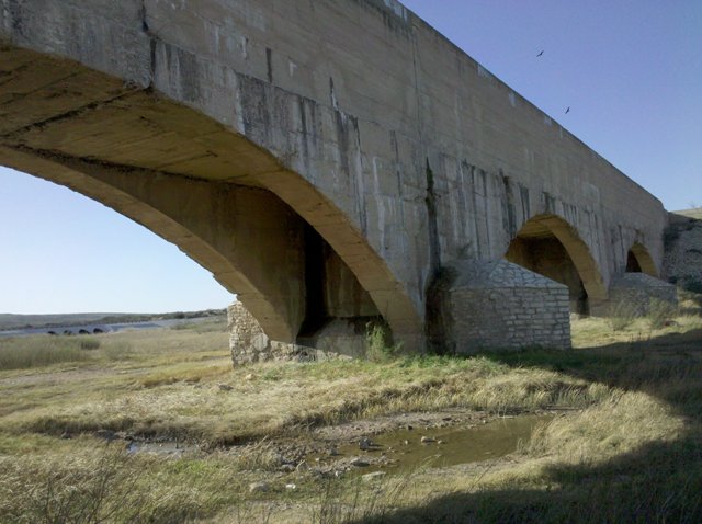
Needing to fill up the gas tank and wanting to explore Balmorhea we drove to town. It is a very small, run down, junkyard of a place. There is a linear park along the highway separating the “main” street in which the irrigation canal runs and they have a few small displays about the area.
We ended up driving about 10 miles to find an over-priced gas station.

The springs run into a lake a few miles away which I wanted to see. The map shows a road around the lake then heading cross country in the general direction of the campground so we plan on taking that. The road to the lake heads out the side of town so we drove through the ten total blocks of the town and onto a small asphalt road for about three miles to the lake.
Strange lake. Signs as you approach saying you have to go to the store at the lake and buy a permit to fish, bird watch or picnic and there’s a $100 fine for not doing so. Since the roads I was traveling were labeled as county roads I wasn’t paying for a permit to drive on them. The lake is rather large with trailers around it in several areas. Sign said campsites were available.

Apparently it’s a private lake and someone owns the entire thing. As I drove around there were sporadic campsites all around as well as a few mobile home village areas. So we start around the lake, stop and snap a few pictures, see the permit store and keep going. A little ways ahead it becomes readily apparent that this is a manmade lake. The road crosses along the EDGE of the earthen dike holding back the lake. It’s probably 25’ wide but there’s a steep and long drop-off on the downhill side and the lake right at the uphill side. Of course an opposing truck came while we were crossing thankfully they were on the downhill side.

The roadway turns to well graded gravel after the lake. As we proceed past the mobile home areas, there are more campsites and the road is getting narrower, assuming because of less traffic. As we pass the last mobile area, the road becomes one lane servicing the few remaining campsites. According to the map the road then heads away from the lake, towards my campground.

Even before the road turned away, it was clear this not a regularly traveled roadway. A lot of considerations needed to be made – this shows up as a road but is clearly crossing private grazing land since we had already passed cattle, the road looks like a decent two track and I’ve got four wheel drive, a full tank of gas, half gallon of water and 5 or 6 hours of daylight. We hit the gas and creep along taking in the feeling of being in the middle of Texas in a BIG field.

The ‘road’ starting becoming a little less defined as we crossed a couple small washes and multiple routes had previously been used. Following the tightly zoomed GPS closely I was able to tell when I got off track and tried to head back towards the route. At this point all the paths have become too narrow for the truck so the prickly bush that can survive in this desert is scratching along the sides. Scratches are like battle scars that add character – right? Four wheel drive was obviously engaged since once you’re stuck it’s often too late. Made it back on track and followed the best looking trail which took me off course again. Well I can’t see a reasonably wide enough trail in the correct direction, look at the map and realize we’ve made it maybe 15% of the way on the “road” according to GPS and decide we need to go back.

Turning around was a real treat but we got it done and bounced our way through the washes and along on the road until we neared the lake again. Passed a calcium chloride truck oiling the road for dust on the way out. Thinking of that, I’m sure it was obvious to anyone who was looking from a distance where I had been driving from all the dust I was kicking up in the field. Had to pass another opposing vehicle on the dike, this time with me on the downhill side then high tailed it passed the store and back towards town.

When we got onto the highway, the truck was pulling BAD to the right. Immediately I assume something must have gotten knocked out while we were off road. I check the pull a couple more times with similar results and start wrapping my mind around needing to get an alignment. The road curved around and there was another straightway so I checked the pull again and it ran straight as an arrow. Suddenly I remember we’re in the middle of prairie and there is a STIFF wind blowing. Whew! Didn’t screw up my truck.

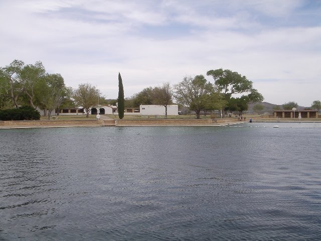
Balmorhea Springs State Park was constructed by the CCC and is the largest swimming pool around a natural spring in Texas, with a surface area of something like an acre and a half. Over a million gallons an hour flow in to the pool. It stays between 72 and 76 degrees all the time and has two protected species of fish and other creatures living in the pool and canals leaving the area towards farmland to be used as irrigation. There are elaborate canal systems here along many of the roads with big gates on offshoots. Since this is what the park is about, I’ve got my mask, snorkel and fins with me and I’m here I decide to check it out.

It’s in the mid eighty’s with about a 20 mile an hour steady wind. Not entirely warm but I figure it’ll be alright once I get in the water. As I arrive at the pool, it’s deserted and I have the run of the place. The pool is 25’ deep circle with two long straight rectangles at 90 degrees from each other. One end is a poured bottom at 3-4 feet deep, the other is a natural bottom between 15 and 20 feet deep. The wind was blowing towards the deep end, where there was a small shelter I hoped may break the wind so I went there. I jumped in and put the snorkeling gear on. It was a VERY cool experience. Crystal clear water, natural bottom, hundreds of little fish hanging out a couple inches below the surface and bigger fish cruising around down low. I would love to tell you that I completed my original plan of swimming the perimeter of the pool but the water was way closer to the 72 degrees than the 76 and there was no relief above the water because of the wind, which was also creating waves. I lasted a few minutes and swam about half of it before making the call. The wind was cold while wet. Made dinner and turned in shortly after dark.

Sunday, April 11, 2010

March 31 - South Llano River State Park to Balmorhea State Park


Slept with window open and blinds up at the end of the bed. Woke up just as daylight was coming around and dozed off and on while watching the animal kingdom wake up. Many birds chirping. Saw an Axis deer wander through my campsite. Finally got up an hour or so later and made coffee. While sitting outside at the picnic table enjoying the peace, a tom turkey wandered through the campsite. Seriously debated staying put one more day but with the holiday weekend coming, for traffic reasons on the highway, I think I’ll move on.
The next stretch is a long one and I’m going to take I-10. Drive was pretty boring and uneventful. Just long. Temperature rose to 95 degrees and trees shrunk to a max height of maybe 10 feet. Humidity is at 6%. This is the Texas from the westerns. Dry, hot dusty and rugged. Forbidding mountains. Makes me think I should have stayed at South Llano another day…
The park was created around a large natural spring which a swimming pool was constructed around many years ago. There are irrigation canals leading away and a manmade wetland has been created to emulate one that was destroyed here when the pool was built. As the sun set, the temperature dropped quickly and the desert creatures came out. Around the wetland it was almost deafening with the sound of insects and birds. A rabbit wandered by our trailer just as dark was falling.

March 30 - South Llano River State Park


Slept in till almost 8:30! Nice and quite I guess. Ran out and got gas before hooking up the trailer and taking off. Stopped in town for a propane tank refill then it was only about a 15 minute drive to the South Llano rover State Park known for its turkey roosting habitat.
Got a nice shady spot at the back of the park looking into the scrub trees and grass. Cell phones barely work here, I get one radio station and of course there’s no television so it’s quite remote and quiet. I’ve barely read at all since starting the trip so I sat down under the shade tree this afternoon to read some more of On the Road. I must have sat there for 30 minutes without hearing any man-made sounds, just birds chirping and the breeze blowing. Absolutely wonderful.
After a while Sunny and I took about a mile walk to the river and back through the woods. Of course she went swimming in the river. Returned to camp and read some more before getting cleaned up and heading into town for dinner.
I stopped at this small family run place and had a great dinner. On the wall were some old pictures of Junction which I was looking at when the owner came by and started explaining them to me. Most were taken in the late 20’s or early 30’s. One was of a mountain lion someone had killed. I inquired about it and she said I needed to see the pictures of the one taken just outside town last fall. She had them at the counter. The cat was longer than a tailgate is wide. Weighed in at almost 150 pounds. And there’s more in these here hills!
Saw a hen turkey and another Black Buck Antelope. Returned to camp and grabbed to Sunny to take a walk to a scenic overlook near the campground before sunset. It was a paved road but parts of it were very steep. We took a side trip to see the park’s water tower then back towards the overlook. Finally we made it to the top and it was worth it. Good timing too and the sun was just going down.
After a break to cool down and snap some photos we headed back. Shortly down the trail we scared up another couple deer. A few hundred yard farther and we heard something off to the right, down the hill and slightly in front of us. Looking there I quickly realized it’s a wild boar. It starts snorting and scratching the ground. I know we do not want to tangle with this so I urge Sunny to just keep going. About then the boar took off away from us down the hill. Scaring up more deer. Sunny wanted nothing more than to go chasing after whatever that thing was that just ran away from us! All I could think about was mountain lions!
We made it back to the campground unscathed after seeing several more whitetails. Sat outside listening to the last of the birds for the evening, hearing a few turkey gobbles and waiting to the light of day was gone. Mosquito’s started showing up and we headed in for the night. Kept writing and reading till sleep.

March 29 – Garner SP to Junction


It was a bit of a cool morning and we caught a great sunrise over the mountain our camp is at the base of. Got around and on the road. Saw y first Tom turkey of the season as we were leaving the park. Travel went well without any traffic except a few semis heading the opposite direction. Pulled into a little town named Junction and found a Super S Grocery store. Stopped for supplies and decided to stay at my first KOA campground there in town. I wanted a few amenities for the night and they had cable, WIFI and Laundry at their park located on the bank of the North Llano River. It was a nice park with friendly people but it’s pricy. $18 to do four loads of laundry! At least it’s done. Wandered around with Sunny and talked with campground folk. Got a recommendation for some good barbeque in town so went and got a plate. I mentioned sunny and they gave me a big container of scraps for her. Talk about a dog in heaven! There is a flock of domesticated ducks living in the park and every morning and night they parade from their pen to the river and back. At sunset deer come to the river on the far side so we sat and watch them before 24. Sure was nice to slide into clean sheets tonight…

March 28 – Lost Maples Natural Area


Cooked breakfast for the first time in a while and at outside in the woods. With a desire to see the Lost Maples State Natural Area and drive some more of the scenic roadways, we took off. Saw a wild turkey foraging on the side of the road. There is not a cloud in sky and the drive is all it’s reported to be, up and down hills with hairpin curves. Glad I didn’t pull the trailer through this. The Lost Maples area is serene. We took a big hike over 5 miles which took us along the river, 450’ up and hill and back down. The walk was awesome. Only twice going up did I have to lift sunny up and over a big obstacle. We were both glad to make it to the top that’s for sure!
Saw a Black Buck Antelope along the road on the return trip. Stopped off in Leakey for gas and was amazed to find a station without pay at pump. It’s been quite a while since I fueled up with a pump that old.
I had forgotten about the central time zone thing and caught just the last minute or so of the MSU basketball game on-line. Made dinner and tore apart and cleaned my backpacking stove.

March 27 – San Antonio to Garner State Park


Up early to catch the sunrise here at Top of the Hill. It was pretty. Packed up and headed out on what promised to be a very scenic drive. Our destination is Garner State Park about 60 mile west in the Hill Country. The drive on TX16 to us through Bandera, which is supposed to be the most true cowboy town in Texas. Well today it was a biker town. The roads are well known for good riding and apparently this weekend there is a gathering called Thunder in the Hills. Hundreds of bikes on the roads. After Bandera we turned south towards the town of Utopia which is nestled in this plain between mountains and from a scenery perspective lives up to its name. The road through the hills is VERY curvy and hilly. One hill in particular stands out which was signed at 25 mph because it was so steep and curved at the top. It was about all I could do to maintain 25 going up the hill with my foot IN the gas.
Arrived a Garner State Park. I went inside the office and was surprised to find a waiting room with numbers and a separate counter area with two people working the five stations. After about a 20 minute wait my number was called, we got registered and headed to our site. Sunny and I took a short walk near the campground then headed to the local store about 9 miles away in a town called Leakey. They have one ‘general’ store with basic supplies. Thankfully all I needed was cooking oil to fry up some of the catfish I have in the freezer from Morgan City. After leaving the store, we took a less than direct route back to the park. As we pulled into Garner, a herd of probably 20 whitetail deer were crossing the road. We split the heard and half run left forward while the others turned around and high-tailed it away. We got back to the trailer, put a package of catfish in water to thaw and headed out on a more substantial walk than this afternoon’s. It took us about a mile and half, up the old park access road, which had a couple overgrown scenic overlooks and up about 200 feet in elevation. Scared up a couple whitetail on the walk. Got back and cooked up the catfish nuggets, which by the way, Sunny is a big fan of!

March 26 – San Antonio


Headed to San Antonio today to check out the Alamo and riverwalk. My campground is about 45 minutes north of town so I went south on US 10 into town. The Alamo is in the heart of San Antonio so we took a couple highway interchanges and then GPS got me right in front of the Alamo. I found a pay parking spot close by and walked to the fort. There were a lot of people there touring.
The plaza is nice and what remains of the fort and courtyards have been well preserved and are very nice gardens. I spent maybe an hour walking through the buildings and grounds before heading down the street to explore some of the Riverwalk. I was somewhat surprised to find that, unlike Austin’s parks along the river, this is basically a sunken sidewalk running along both sides with a few bars and restaurants accessible from the walk. It is unique and I can see how a lot of fun could be had there with the right crowd. There are water taxis running up and down the river which you can catch a ride on or tour from.
Beyond the river walk I found Main Square where the courthouse and San Fernando Cathedral are located. With an exploring attitude I wandered into the Cathedral to be surprised by a tomb just inside the door. It was the remains of Davie Crocket, Jim Bowie, and Truman laid to rest right in front of me. Quite a bonus for just exploring!
After the cathedral, I debated heading to some of the NPS Missions south of downtown but having my fill of history and traffic for the day I headed back to do some trip planning. Made plans for the next few days and took Sunny on a sunset drive back on the small road we came in on yesterday as well as down a couple side roads to see what we could find. Beautiful country that’s for sure.